James Milner was sent as a convict in March 1831 aboard the transport ship “Argyle” to Van Diemen’s Land, now Tasmania. I learned about this cousin from Roy Milner a fellow Milner researcher in England. I had verified the details about James Milner using the wonderful convict database at the Archives of Tasmania website. James was also located in the 1842 census as the head of the household, working as a servant on the land of Fred Brock Esq., located 6 miles from Carlton, in Carlton Parish.
While on my lecture tour in Australia, I learned a lot about the life of convicts and their place in society by reading and visiting a number of prisons. Given the census information I had, I wanted to see if I could physically put James Milner on the ground somewhere in Tasmania. The first stop was the map collection at the Tasmania State library in Hobart where I hit pay dirt. With the help of staff, I located a map of Carlton Parish naming land owners. George Frederick Brock received a land grant of 2560 acres. This has to be Fred Brock, Esq. of the census. More research is needed on this person as he must be significant somehow, especially when one realizes that the largest land grant in Tasmania was 3,000 acres given to the governor, near Richmond. The Brock land abuts the small community of Copping on the modern road from Hobart to the penal settlement at Port Arthur.
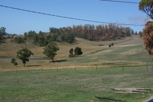
This property in many respects was in an ideal location as we had planned on visiting Port Arthur. We had seen advertisements for the Copping Colonial and Convict Museum so we drove to Copping. The name of the museum was a big misnomer and the owner had no information on even the major landowners in the area. We retraced our steps a little along the road until we found a farm track taking us up onto the top of the hill that would give us a great overview, looking South onto the Brock land (see picture). There was no one home at the farm, but I did take a bunch of photographs of the surrounding countryside.
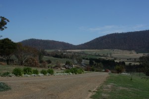
The census was taken January 3, 1842 at the height of the summer. I was there March 7, thus a little later in the Australian summer. The grass I saw was probably drier and browner, the creek was drier, but the rolling hills, with patches of woodland would have been just as beautiful. Google Earth shows that there are some vineyards or orchards over the crest of the hills to the south but they are not visible from the house where I stood. There was only one private road, heavily posted with keep out signs, and with lots of truck traffic that appeared to go a little further south onto the property, which had been identified as the municipal tip. We did not take the private road.
I have James Milner on the ground in Carlton Parish, Tasmania. Now I need to find out more about George Frederick Brock, Esq. for whom he appears to be working. Ah! The joys of family research, always leading to more questions.
